Interview by Holli Cederholm
This spring, the United Nation’s body for assessing science related to climate change, the Intergovernmental Panel on Climate Change (IPCC), issued its sixth assessment report (AR6) on climate change since the group’s establishment in 1988. The report was announced to the world with a press release declaring: “Urgent climate action can secure a liveable future for all.”
The Earth’s temperature has already risen nearly 1.1 degrees Celsius (2 degrees Fahrenheit) since 1880, when global temperature observations were first recorded.
The 2015 Paris Agreement defines a global warming of 2 degrees Celsius as the upper limit for life as we know it, with 1.5 degrees as a target that could help minimize the worst effects of climate change around the globe. The IPCC’s 2023 report, which was approved during a week-long session in Interlaken, Switzerland, in March, says that hitting 1.5 degrees Celsius is now inevitable. To curb the Earth’s rising temperature to 1.5 degrees, the report’s authors say that emissions will need to be cut nearly in half by 2030.
Just days after the report’s release on March 20, 2023, with the clock set at less than a decade and ticking, I spoke with Sean Birkel, Maine state climatologist and research assistant professor with a joint appointment to the Climate Change Institute and Cooperative Extension at the University of Maine. As a federally recognized state climatologist, Birkel provides climate services, including collecting, disseminating and interpreting climate data to help inform decision making and planning. Birkel’s research background is in climate variability and modeling. In particular, he studies climate variability over a range of time scales, including paleo climate and modern climate, and evaluates climate projections for the future. This work includes writing computer code to process and visualize climate and weather datasets (check out his website, climatereanalyzer.org, developed with support from the Climate Change Institute). Birkel is also developing the Maine Climate Office, and works with colleagues at Cooperative Extension to provide climate and weather data to farmers.
This interview was edited for clarity, and some responses were submitted via email.
As Maine’s State Climatologist, you collect, disseminate, and interpret climate data to help inform decision-making and planning. What kind of data are you collecting and how?
Sean Birkel: I work primarily with existing datasets and models that are publically available from NOAA (National Oceanic and Atmospheric Administration) and the National Weather Service. These include surface weather observations, a type of recent historical climate data product called reanalysis, and also climate models that project future conditions. I use these datasets to better understand climate patterns, trends and impacts, and then contribute findings to reports such as the Maine’s Climate Future series, and, as a member of the Maine Climate Council’s Scientific and Technical Subcommittee, I contributed to the 2020 report “Scientific Assessment of Climate Change and Its Effects in Maine.” In my extension role I also provide weather forecast and seasonal climate outlook information to growers by contributing to newsletters and fielding individual data requests. I also disseminate climate and weather data and visualizations through climatereanalyzer.org and the Maine Climate Office website.
Although I do not currently maintain weather stations, I am interested in historical climatology and recording anecdotal information, which can be very important to have alongside data observations from weather stations. For example, what were conditions like 30 or 40 or 70 years ago? What do people remember? And, in particular, what information at the local scale might not be captured in station data? There are written records and photographs of Penobscot Bay when it froze during five or six really cold winters in the early 1900s. There’s also still some living memory related to that: people whose grandparents said that, when they were children, they could walk across to Vinyl Haven from the mainland. And in the book “History of Castine, Penobscot, and Brooksville, Maine” published in 1875, there is explicit mention of the bay having frozen from Castine to Camden in the winter 1780-81 (during the American Revolution) so as to permit travel over the ice. This document also notes the bay froze three consectutive times in the early 1800s, starting with the winter of 1815-16 — this happens to follow the 1815 eruption of Mt. Tambora in Indonesia, which is now well known to have cooled climate worldwide and caused the 1816 “Year Without a Summer” in New England that devastated crops!
In relation to agriculture, I’m very interested in collecting observations from people describing the changes that they’ve seen — especially over the past 20 or 30 years — and how these changes have been impacting their operations on the farm. We can certainly analyze weather station data and in a quantitative way say how the climate has been changing, but to hear what that means on the ground, from the people who are working every day in the field about how they see their own livelihoods being impacted, that’s information I’m very interested in.
We’ll get to some ag-specific questions shortly, but first I wanted to talk about your climate modeling work. You’ve been working on the Climate Reanalyzer since 2012, and I’m wondering how visualizing data over the course of the last decade has helped you gain insight about Maine’s climate.
Birkel: My purpose in developing the Climate Reanalyzer website has been to bring together a variety of publicly available climate datasets. Different types of observations can be ingested into a framework called “reanalysis,” where a weather model then calculates heat and moisture flow to estimate the state of the atmosphere at any given moment in time at the surface and through the vertical column. State-of-the-art reanalysis products begin with the era of continous satellite monitoring (generally beginning in 1979) and can also extend to when weather ballon observations became widespread in the late 1940s. “Reanalyzer” is in the name of the website because it was started initially accessing reanalysis.
To give you an example of how data visualization can provide insights … A former Ph.D. student of mine examined summer precipitation in Maine and the Northeast, and published results indicating that our region tends to see more rainfall when high pressure blocking (picture a loop in the jetstream that persists for days) develops over Greenland. This was a prominent large-scale teleconnection in summer from about 2004-2015 when Maine saw a historically wet decade. This particular project started after using Climate Reanalyzer to make a mean sea level pressure map for the decade in question, and the spatially coherent pattern over Greenland seeded the idea.
Could variability produce another wet decade? Or will short-term drought become more common here in summer as the climate warms? These are the types of questions that can be investigated with reanalysis and climate models to help provide guidance for the future.
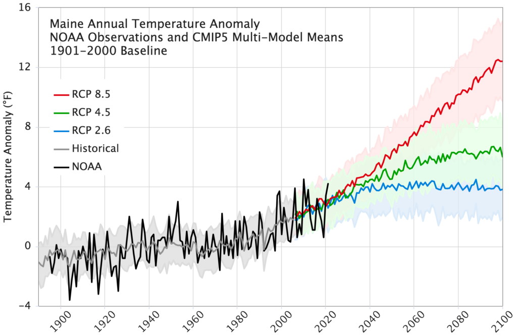
Fig. 1. Maine Annual Temperature Anomaly: NOAA (National Oceanic and Atmospheric Administration) Observations and CMIP5 (Coupled Model Intercomparison Project Phase 5) Multi-Model Means. Representative Concentration Pathways (RCPs) are associated with a range of potential global greenhouse gas emission and sequestration scenarios; the pathways are numbered based on the expected watts
per square meter produced (a measure of how much heat energy is trapped). RCP 8.5 is the pathway representing the highest greenhouse gas emissions; RCP 2.6 represents the least (assuming a consistent decrease in emissions with net negative emissions by the end of the century). Figure Courtesy of Sean Birkel
From warmer, shorter winters to hotter, longer summers, can you provide a synopsis of changes to Maine’s climate based on climate modeling you’ve conducted?
Birkel: Maine’s climate is warmer and wetter than it was a century ago. Since 1895, Maine’s climate has warmed about 3 degrees Fahrenheit. Also, during that time, Maine’s total annual precipitation has increased by about 6 inches.
We’ve seen, especially the last 20 years, a change in overall precipitation towards a tendency for heavy, or extreme, precipitation events that can deliver a lot of rainfall in a short period. This is one of the challenges that growers are dealing with: how to manage heavy rainfall that can damage crops, produce runoff. The warming worldwide is associated with the warming ocean, which enhances evaporation over the ocean and entrains more moisture in the atmosphere, which in turn provides the moisture for these extreme rainfall events. We’ve also observed a tendency towards what are called atmospheric blocking patterns in which a particular weather pattern might persist in what becomes either a cold wave or heat wave.
What other climate and weather impacts are affecting farmers in Maine?
Birkel: Another impact is the longer growing season, which on the one hand can be beneficial, but can also be a challenge because it’s coming with additional heat that may be more or less beneficial to certain crops. This is in conjunction with short-term drought that can be very detrimental, as we’ve seen in recent years, perhaps most notably in 2020. It’s managing these extremes that are happening more frequently, both in terms of precipitation delivery and this tendency towards short-term drought that’s emerged in the last several years.
Even though the growing season is lengthening, variability in the weather can still produce late-season frost in the spring or early-season frost in the fall. There’s an interesting potential to have a growing season with significantly more accumulation of growing degree days than 30 years ago, yet still end early because of an event-driven killing frost.
Then there’s the much milder winters that we’re seeing overall and an earlier onset of mud season — we saw an extreme of the latter this past winter — and mid-winter thaws that disrupt dormancy for plants and insects. In the spring, warm temperatures and an early snow melt can lead to soil dryness and reduced stream flows heading into the growing season. The detrimental hydrological effects of early snowmelt could be offest if in a given spring above-normal rainfall developed. However, with warmer temperatures and a shorter snow season there is increased potential for dryness.
Circling back to what you mentioned earlier about an interest in anecdotal evidence in relation to the data that you’re analyzing, I’m wondering if there are any anecdotes that have stuck with you or influenced your work?
Birkel: In 2009, it was a very wet summer, and I understand that some growers reported fields going fallow because there was too much rain. As I mentioned earlier, the wettest decade on record in Maine was from 2004 to 2015, which followed the early 2000s drought. The Maine Drought Task Force had last activated in 2002 and then not called at all until drought conditions developed in the summer of 2016. I have heard people relaying their experiences of not having water concerns for 10 years. People who started farming in the mid-2000s generally didn’t have to worry about irrigation.
I was one of those people. I believed rain comes from the sky; you don’t need to water.
Birkel: Then 2016 hit! That year was a very interesting year for a number of reasons. There was a mega El Nino (warming of the equatorial Pacific Ocean surface waters in association with changes in weather patterns worldwide). There are only two others of similar magnitude on record, 1982-83 and 1997-98, and then of course this one in 2015-16. If we look at the summer atmospheric pressure field on average over the Arctic since 2016, the pressure has been relatively low in comparison to the decade or so before. And our part of the world got drier — this ties in with the summer precipitation study that I mentioned. The coincidence between the 2015-16 El Nino and changes in the Arctic and here in Maine suggests there could be a teleconnection. The El Nino could have been a trigger, but more research is needed to say for certain. I have to wonder if these last few years of dryness is a part of variability, and maybe we’ll see a return to several wet years. We don’t know. I haven’t yet done a thorough analysis, but there could be a decadal type variability involved.
Speaking of El Nino … The Gulf of Maine is warming faster than 99% of the world’s oceans. Can you speak to water acting as a heat sink and potentially hiding some effects of climate change, and how this phenomenon may or may not interact with La Nina (when the water is cooler than normal) and El Nino (when the water is warmer than normal)?
Birkel: First, yes, the Gulf of Maine has warmed significantly, and there have been several marine heat waves since about 2010. The warm-water season has lengthened by three or four weeks since the 1980s — all of which has had a huge impact on the marine ecosystem and fisheries. The surface waters of the North Atlantic as a whole have been tracking at record temperature in recent years based on NOAA datasets going back to the mid-1800s.
The warm North Atlantic also has a significant impact on our climate. Many people have noticed that recent summers, especially in August into September, have felt more humid than they used to. I grew up in Bangor, and I’ve certainly noticed that. The data show most of the relative lengthening of the warm season has occurred in late summer into early fall.
In terms of the oceans as a heat sink, they are storing the majority of the excess heat accumulation resulting from greenhouse gas emissions. For the past three years there has been a rare “triple dip” La Nina where cool waters from depth have been brought to the surface and in effect moderated global temperatures. However, La Nina conditions have ended, ENSO (the El Nino Southern Oscillation) is in neutral state heading toward El Nino, and the mean global ocean surface temperature has reached record levels — warmer now than during the 2015-16 El Nino. It’s been quite shocking to see the values go “off the chart” this April!
On the opposite end of the temperature spectrum, Mainers witnessed a spike of deep cold this past winter due to a polar vortex disruption that drove frigid air from the Arctic southward. Is global warming causing these types of disruptions to the polar vortex? Can we expect to see more instances of plummeting cold in the future?
Birkel: Yes, that intense cold wave in early February followed a sudden stratospheric warming, which led to the breakup of the polar vortex. These phenomena were first observed many decades ago, and we don’t know for certain yet to what extent climate change will impact the frequency and severity. However, we are seeing more extremes in general, and there is research that suggests blocking patterns (waves in the jet stream that persist for days) from which both cold and heat waves develop could become more common. Other recent examples of these extremes are the March 2012 heat wave that brought temperatures into the low 80s (March 21-22) in parts of southern and central Maine, and the monthlong cold of February 2015. February 2015 was the coldest in Maine since 1934, and it developed from an unusually persistent ridge-trough wave pattern over North America where record high temperatures were seen across much of the west, while intense cold was funnelling down from the Arctic over the east. The warming in the Pacific led into what became the 2015-16 mega El Nino — yet another example of an extreme!
How will the stratosphere dynamics change in the future? Does a warming world mean more stratospheric disruptions that can produce these intense cold waves in the middle altitudes? It’s possible, but we don’t know for certain yet.
Does your work forecast what impacts to agriculture we might expect to see in the future? You gave an overview of what’s happening now but I’m wondering, will it be more of the same or what other impacts might we see?
Birkel: When we look into the future, when we look at the results from climate models and what they project for Maine through this century to 2100, Maine could see a warming of anywhere from 2 to 10 degrees Fahrenheit. That large range of uncertainty is due primarily to the range of possible greenhouse gas emission trajectories worldwide. With these possible temperature increases we could see anywhere from a two-week to four-week increase in the length of the growing season. Likewise, there would be a comparable reduction in the length of the winter snow season.
Maine’s climate is projected to get wetter on the order of 10 to 20% more annual rainfall in a given year by the end of the century. How the seasonal distribution of precipitation changes is uncertain: some seasons could see either increases or declines; and there is still the potential for decadal variability. As highlighted in the Maine Climate Council’s scientific assessment report, we cannot say for certain whether or not drought will become more or less prevalent, but there is a tendency towards more extremes. We should be prepared for the possible outcome of more frequent short-term impactful droughts, such as what we have seen in in recent years. However, with an overall wetter climate there could still be years in which the additional rainfall offsets the increased drying effect of warmer temperatures, via increased evaporation and evapotranspiration.
The IPCC recently released its sixth assessment report (AR6), which states that global warming is on track to reach 1.5 degrees Celsius above pre-industrial levels — regardless of how much greenhouse gas emissions rise or fall over the course of the next decade. What does this mean for Maine and for the local food system?
Birkel: 1.5 degrees Celsius is a lot — but this is in reference to an 1850-1900 baseline. The AR6 report indicates an expected increase of 0.4 Celsius (or about 0.7 Fahrenheit) over the next 20 years. Here in Maine, this is comparable to the mean annual warming that has occurred over the past 20 years. The implication is a continuation of climate trends we have observed recently. Perhaps most significant would be the addition of several days to the growing season (and more overall heat accumulation), and likewise further diminishment of winter. On average, later frosts in the fall, more frequent thaws in winter, earlier onset of spring, and higher temperatures in summer will lend to increased evaporation and drier soils if the weather in a given season produces precipitation deficits.
It’ll be interesting to see, because there’s still variability within the system and some regions might be more impacted during that time than others because of the variability associated with Enso, El Nino Southern Oscillation, which operates over a three-to-five-year time scale. The focus of the additional warming might be on one region over another and so it wouldn’t be just a linear increase in Maine, but those numbers don’t bode well. We should plan for a warmer climate and expect that impacts we’ve seen will be exacerbated.
The authors of AR6 also state that to keep the Earth’s temperature from rising beyond 1.5 degrees — and to maintain a “liveable future” — that immediate action is needed. Climate change, for many, is an incomprehensibly large problem — and it is causing climate anxiety that might lead to inaction. You’re deeply immersed in climate change. How do you find hope in your work?
Birkel: I think that we’re in a good place here in Maine because, although we face significant challenges and Maine’s climate will be much different 30 and 50 years from now, the region is not facing unmanageable heat and catastrophic drought. Instead, we are facing warmer temperatures, a longer growing season, and more precipitation overall. For agriculture I think there are both potential benefits and caveats. The challenge is how to adapt to these changes and manage some of the extremes that can develop, such as the possibility of more common occurrences of seasonal drought and periods of heavy rainfall that produce runoff and flooding. Coastal communities will have to implement adaptation measures as sea level rise produces more erosion and flooding that affects both ecosystems and civil infrastructure. Warming in the Gulf of Maine and how it impacts the marine ecosystem and fisheries in the coming decades is a major concern. But Maine is taking aggressive action on climate change now in preparation for the future. And that gives me hope.
This article was published in the summer 2023 issue of The Maine Organic Farmer & Gardener, MOFGA’s quarterly publication.