 |
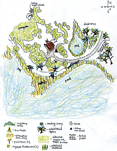
| Use Google Earth to print a map of your farm or garden area, then trace the outline of that map to create your own landscape design. Map courtesy of Google. Garden plan by Victoria Scanlan Stefanakos. |
 |
By Victoria Scanlan Stefanakos
Last spring, whenever I looked up from the mud while trying to outrun the rain to plant two peach trees, one Nanking cherry bush, three highbush blueberries, 100 strawberry plants and a new raspberry hedgerow, I was madly envisioning where the rest of our food would go. The tomato and pepper seedlings, the greens waiting in flats, and the pumpkins, gourds and corn all needed fertile homes too.
This was my “year of the garden” – the year I stopped dreaming and reading and surfing YouTube (for swale-building tutorials, no less) … and STARTED PLANTING. It took me a few years, and as many meager harvests, to locate just the right site for really productive fruit and vegetable gardens. This process took a while because, along the way, I became obsessed with permaculture and forest gardening. Lucky for me, deep contemplation is as necessary as good compost for gardens that are high-yield, low-maintenance and as perennial as can be.
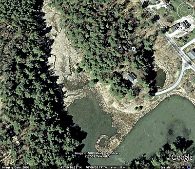
Well, the tines hit the topsoil this spring, and our new hillside garden got under way – especially after I learned about a useful tool from my friend Lisa, who runs our impressive local permaculture meetup (www.meetup.com/portlandpermaculture/). She told me that she uses Google Earth to track the layout and patterns of sunlight and even to make measurements on properties for which she’s designing gardens.
I downloaded it from www.earth.google.com, zoomed into our location (the accompanying image is a snapshot of our fledgling homestead), and then traced everything from existing gardens to a tiny future vineyard. A girl’s gotta dream, right?
(From Victoria Scanlan Stefanakos’ blog, www.projecthomestead.com/)