Permanent Site Planning Committee
 |
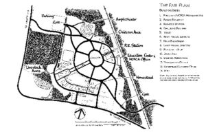
| 1998 Fair Plan. Kent Associates, Planning & Design, Gardiner, Maine. |
By Brian Kent
Planning the layout of MOFGA’s new site in Unity began in late 1996, when members brainstormed some rough plans, and began to define what the flat, featureless, 35-acre field and its surrounds would have to accommodate. The Permanent Site Planning Committee, led by Ellis Percy, set the agenda: Develop a plan to accommodate Common Ground Fair (and other fairs), MOFGA’s headquarters, a model farmstead (with fields and orchard), and large conferences and educational gatherings. No small order, given that the Fair must host some 70,000 visitors and their cars over a three-day period, while the farmstead must operate year-round and be run by one or two people living on-site.
This challenge was taken up by four volunteer planners: Tom Hepp, Conrad Heeschen, David Neufeld and me. Over a period of months, we refined our ideas, visited the site, and held many discussions with the Site Committee, Russell Libby, Susan Pierce, and members of the Large Animal Committee. Everyone agreed that a central “common ground” and gathering place was needed and that Fairgoers should approach the site from parking areas to the northwest and southeast. We also agreed that the headquarters building would best be located in the northeast segment of the site, near the Belfast and Moosehead Railway line that runs through the land, but we were unable to agree on a detailed design.
In December, given the complexity of the project, the tight timeframe, and the need to finalize a design suitable for submission for local and state permitting, the Site Committee elected to hire me. What follows is a description of the master plan that was approved by the MOFGA Board of Directors in February, 1997.
 |
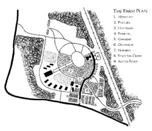
| 1998 Farm Plan. Kent Associates, Planning & Design, Gardiner, Maine. |
The Master Plan
The Fair Plan illustration and aerial perspective sketch show the overall layout of the site, ready to welcome thousands of Fairgoers, exhibitors, and their animals on September 25, 1998. The Farm Plan shows how the site also serves as an agricultural conference and educational center, as MOFGA’s permanent offices, and as a farmstead with model home, maintenance buildings, apprentice accommodations, demonstration gardens, fields and orchard.
Getting Around
One of the biggest challenges facing us was how to design a system of broad pathways that would allow people, animals, trucks, wagons, wheelchairs, and emergency vehicles to move around safely. The solution was to:
• exclude all private vehicles from the Fair site;
• introduce a wagon shuttle, from the parking areas to the outer loop, for the very young, the elderly, and infirm;
• establish a peripheral one-way system, behind the barns and sheds, for exhibitors, trucks, and trailers;
• plan for up to 15 percent of Fairgoers to arrive by train;
• and reserve the majority of the site “roads” for pedestrians (while allowing for emergency vehicles on the outer loop road).
During most of the year, cars will reach the MOFGA offices and education center parking area from the south, past the farmstead, by way of the outer loop road. (See the Farm Plan.)
The Pattern
While the “circles” and “spokes” on the plan define areas for different fair events, buildings and tents, and cover below ground utility rights-of-way, they also establish an easy-to-understand pattern to guide visitors to various exhibits. Four major elements comprise the Fair layout.
The Gateways. Fairgoers will approach from three directions: the two (northwest and southeast) gateways/ticket booths and the rail station.
The Inner and Outer Circles: The inner loop defines a ± 2-acre, oval common ground that will be an open gathering space. The outer loop provides access to most exhibits and has a diameter of about 1000 feet – a comfortable five minute walk.
The Axis: This broad avenue provides a bold point of reference midway between the two major gateways. It also links the railroad station and main exhibition building to a large animal exhibition building. Not unlike the Greek temples of yore, it makes a visual connection to distant fields on hills to the southwest.
The Spokes: The radial pathways segment the site, link the major elements, and match the points of the compass.
Land Uses
Much of the 35-acre site will be farmed. Most of the area will be hayed, and the fields around the farmstead will be used for demonstration gardens, crops, and an orchard. The surrounding woods are to be managed using low impact harvesting techniques.
During Fair days, the site comprises two major zones, linked by the central axis and the Common Ground open space. To the north and east are crafts, cultural events, and the huge, timber-framed exhibition/education center; a 2000-seat outdoor amphitheater and children’s center are also located on the north side of the site.
On the west and south are animal barns and shelters, fields for sheep herding and horse and cattle demonstrations, poultry buildings, farm product displays, and the farmstead itself. Space for on-site camping is provided to the west and north of the fairgrounds.
Landscaping
Ultimately a richly landscaped site with avenues, groves of trees, gardens, sculpture and, of course, agricultural crops is envisioned. For now the Landscape Committee (chaired by Ernie Glabau) has set modest goals. A good conservation mix has been seeded, and the orchard areas are being planted to cover crops. Donations for a site nursery are being sought, and Lloyd Brace has an ambitious rose planting program underway. However, a master landscape plan will be developed only after we see how the site is used at Fair time and after the main buildings are in place and in use.
Plan on joining us, next year, to start planting!
Permanent Site Planning Committee *
Conrad Heeschen
Brian Kent
Rick Kipp
Bob Lamontagne
CR Lawn
Russell Libby
Ellis Percy
Susan Pierce
Steve Plumb
Bob Sewall
Matthew Strong
* members involved with the Master Plan
